Resultats de la cerca
Es mostren 14794 resultats
Ararat

Al fons, Mont Ararat, al Caucas
© Fototeca.cat-Corel
Massís
Massís volcànic de l’altiplà anatolioiranià, a la Turquia oriental, dins el territori històric d’Armènia, és el punt de divisió dels actuals estats d’Armènia, Turquia i l’Iran.
S'alça fins a la regió de les neus permanents en dos pics alineats en la direcció del Caucas Büyük Aǧri Daǧi 5 165 m i Küçük Aǧri Daǧi 3 925 m La tradició l’ha fet aparèixer com el lloc on s’aturà l’arca de Noè La primera ascensió al massís fou efectuada per F Parrot el 1824 La primera ascensió catalana fou realitzada el 1968 per Venanci López de Ceballos i Jordi Pons, en ocasió de l’Expedició Trans-Himàlaia L’Ararat © Xevi Varela
Antitaure
Massís
Massís muntanyós de Turquia, que forma part del Taure central.
El cim més alt és el Berit Daǧ 3 014 m És cobert de boscs i difícilment penetrable Darrerament ha estat poblat per nòmades turcs i kurds
Gotland
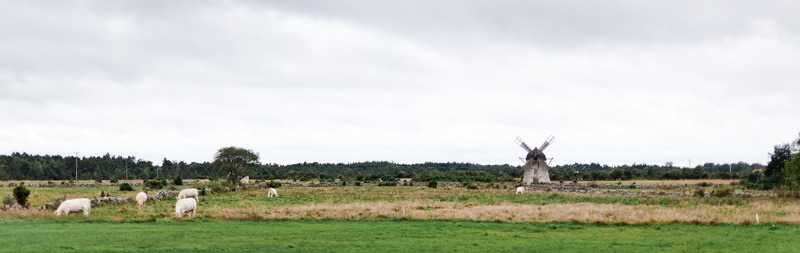
Paisatge rural de Gröttlingbo, a Gotland
© Tuukka Ervasti/imagebank.sweden.se
Illa
Divisió administrativa
Illa i län
de Suècia, situada a la mar Bàltica, a 90 km de la costa oriental sueca.
La capital és Visby És un altiplà de menys de 100 m d’alçada Les costes són retallades i formen penya-segats de 20 a 30 m La població, escassa, es dedica principalment a l’explotació forestal i a la pesca té ramaderia ovina i bovina
Göteborg-Bohus
Divisió administrativa
Län de Suècia fins el 1998, quan s’integrà en el de Västra Götaland.
La capital fou Göteborg
Göteborg
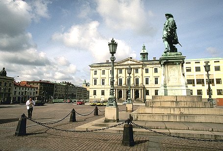
La ciutat de Göteborg, el port pesquer de la qual la converteix en un dels centres econòmics més importants de tot Suècia
© Corel Professional Photos
Ciutat
Capital del län de Västra Götaland, Suècia.
És situada a la costa occidental de Götaland, a l’estuari del Göta, prop de la desembocadura al Kattegat La installació de mercaders holandesos influí en l’obertura d’un seguit de canals a través del nucli antic de la ciutat Gamlestaden, molts dels quals han estat emplenats i convertits en avingudes, que formen el centre comercial L’expansió urbana és deguda, sobretot, al port, el qual esdevé port nacional quan, a l’hivern, el d’Estocolm resta blocat pel glaç És un nucli industrial —especialment d’automòbils i electrònica, petroquímica, construcció naval i refineria de petroli— i de turisme…
Götaland
Geografia històrica
Regió geograficohistòrica de la Suècia meridional, la més fèrtil i la de més rendiment del país, amb una intensa vida agrícola i comercial.
La ciutat principal és Göteborg
Göta
Canal de navegació
Via navegable de Suècia que comunica Göteborg, al Kattegat, amb Söderköping, a la mar Bàltica, a través del riu Göta i els llacs Vänern i Vättern.
Té una longitud d’uns 400 km, 96 dels quals són de canal
Giresun
Divisió administrativa
Il de Turquia, a la regió Costa de la Mar Negra.
La capital és Giresun 45 690 h 1980
Ljusnan
Riu
Riu de Suècia (430 km).
Neix a la frontera noruega i desemboca al golf de Bòtnia Hi ha transport de fusta, pesca de salmons i producció d’energia elèctrica
Ljungan
Riu
Riu de Suècia (350 km).
Neix al massís de Helagsfjället i desemboca al golf de Bòtnia Hi ha salts d’aigua, que hom aprofita per a produir energia elèctrica