Resultats de la cerca
Es mostren 8 resultats
Bregenz
Ciutat
Capital del land
de Vorarlberg, Àustria, vora el llac de Constança.
La ciutat baixa Unterstadt , i centre comercial de la població, s’agrupa al peu de l’antiga vila fortificada Oberstadt , l’antiga Brigantium Nucli industrial afavorit per l’increment turístic, és entroncament de ferrocarril Habitada pels celtes i després pels romans, a l’edat mitjana pertangué als comtes de Bregenz i als de Montfort, els quals la cediren als Habsburg l’any 1451 Del 1805 al 1814 formà part de Baviera
Àustria Anterior
Geografia històrica
Conjunt dels territoris de la casa d’Àustria al cercle de Suàbia.
Comprenia el comtat de Brisgòvia, una sèrie de petits districtes a la part sud del cercle, anomenada Àustria Suàbia, la major part del Vorarlberg i el Sundgau i altres possessions menors a Alsàcia Els territoris d’Alsàcia foren cedits a França per la pau de Westfàlia 1648 Brisgòvia i l’Àustria Suàbia passaren a mans d’altres estats alemanys Baviera, Baden, Württemberg, Hohenzollern arran de les guerres napoleòniques i la dissolució del Sacre Imperi Només el Vorarlberg romangué unit a Àustria
Tirol
Regió
Regió dels Alps orientals, dividida entre els estats d’Àustria (Tirol o vall de l’Inn i Tirol Oriental o capçalera del Drava) i Itàlia (Tirol del Sud o capçalera de l’Adige).
És un territori molt muntanyós que s’estén entre Baviera, al N, i el Trentino al S S'hi distingeixen una sèrie de massissos formats per roques metamòrfiques, continuació de la zona axial de la gran serralada alpina, amb altures superiors als 3 000 m l’Ortler Ortles, l’Ötztaler, el Zillertal, el Brenner i l’Alt Tauern a ambdós costats d’aquests s’estenen els Prealps calcaris, amb altituds més modestes Alps de Pusteri, Càrnics, Dolomites, Lechtal A la zona de contacte estructural entre ambdós massissos s’inscriuen els solcs longitudinals de les valls de l’Inn i del Drava, que reben…
Vorarlberg
Divisió administrativa
Land d’Àustria.
La capital és Bregenz Limita al N amb Baviera i el llac de Constança, a l’W i al s amb Suïssa i Liechtenstein i a l’E amb el Tirol, a través de l’Arlberg Pass És travessat per l’Ill, afluent del Rin frontera occidental amb Suïssa, per l’Ach de Bregenz, tributari del llac de Constança, i pels cursos superiors del Lech i de l’Iller, afluents del Danubi El relleu és muntanyós al S, de roques esquistosocristallines al Rätikon i calcàries als Alps de Silvretta El clima és continental alpí, amb hiverns freds i precipitacions abundants Actualment, els recursos econòmics deriven en…
Caríntia
Divisió administrativa
Land
d’Àustria, que limita al NW amb el land
de Salzburg, al NE amb el d’Estíria, al SE amb Eslovènia i al SW amb Itàlia.
La capital és Klagenfurt És una àrea muntanyosa, de clima continental, travessada per la vall del Drava i pel seu afluent el Gail És formada per dues regions la Caríntia occidental, de valls abruptes i altes muntanyes, com les Hohe Tauern, que forma el límit amb la província de Salzburg, i la Caríntia oriental, que comprèn la fèrtil despressió de Klagenfurt, constituïda per sediments morènics, separada d’Itàlia i d’Eslovènia pels Alps Càrnics i els Karawanken La població de Caríntia, majoritàriament alemanya, comprèn un 4% d’eslovens els catòlics constitueixen el 83% i els protestants l’11%…
els Alps
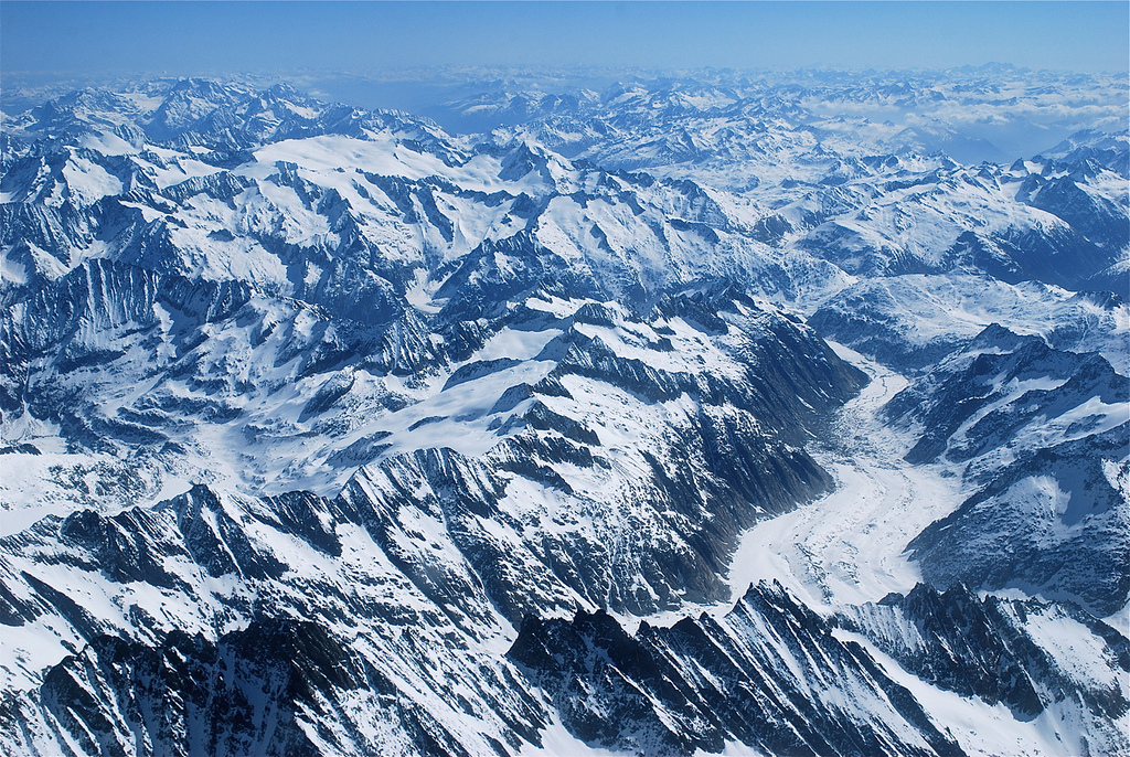
Vista general dels Alps
© Xevi Varela
Serralada
Principal serralada de l’Europa Occidental que al llarg d’uns 1.300 km forma frontera entre Itàlia, França, Suïssa, Àustria i Eslovènia.
Els límits El límit septentrional el constitueixen d’W a E la vall del Roine, l’altiplà suís i l’altiplà de Baviera Pel S, els Alps cauen bruscament sobre la plana del Po, que ocupa tot el N d’Itàlia En aquest llarg recorregut generalment hom distingeix els Alps occidentals, des de la Mediterrània fins al Mont Blanc, els Alps centrals, que ocupen el S de Suïssa i Àustria fins al pas de Brenner, i els Alps orientals, que per una part es perden dividits en múltiples digitacions a la plana hongaresa i que pel S continuen en les serralades…
Zugspitze
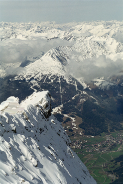
Vista aèria del Zugspitze
© Stock.xchng
Cim
Cim dels Alps Bavaresos, a l’alta Baviera, Alemanya, a la frontera amb el Tirol austríac i al SW de Garmisch-Partenkirchen.
Amb 2 964 m, és l’altitud màxima d’Alemanya
Salzburg
Divisió administrativa
Land d’Àustria, entre el Tirol a l’W, Caríntia al S, Estíria a l’E, Alta Àustria al NE i Baviera al NW.
La capital és Salzburg Correspon a la conca del riu Salzach afluent de l’Inn, entre la serralada dels Tauern al s i les muntanyes dels Alps de Kitzbühel al N A causa del caràcter muntanyós del territori, té una densitat de població 67 h/km 2 est 1990 inferior a la mitjana del país El Pongau, regió que correspon a la vall inferior del Salzach, és la zona més poblada i més industrialitzada D’economia forestal i ramadera, posseeix jaciments de sal, ferro i coure Té importància la producció d’energia hidroelèctrica Indústria diversificada alimentàries, de la fusta, químiques i metallúrgiques d’…