Resultats de la cerca
Es mostren 25 resultats
el Banat
Geografia històrica
Regió de l’Europa oriental estesa entre els Alps de Transsilvània (Romania), el Danubi i els rius Tisza (Hongria i Sèrbia) i Mureş (Hongria i Romania).
És una àrea de plantes fèrtils, essencialment agrícoles La part occidental, que prolonga l’agrera terra baixa hongaresa, malgrat que resta seca a l’estiu, produeix excellents collites de blat, moresc, tabac, cànem, verdura i fruita, combinades amb la cria de bestiar i la sericicultura i, en petits sectors, amb el conreu de l’arròs A l’est s’estén una àrea muntanyosa monts del Banat , amb vessants coberts pel bosc i amb dipòsits de mineral de ferro i de carbó, base d’una indústria siderúrgica i metallúrgica local El principal centre econòmic i cultural és Timişoara Romania Conté…
Dobrudja
Regió d’Europa sud-oriental compresa entre el curs inferior del Danubi i la mar Negra.
Ocupa la vall dreta i el delta del riu, que voreja el massís granític paleozoic de Tulcea, molt erosionat al sud afloren les calcàries terciàries La costa és baixa i arenosa, amb nombroses llacunes litorals Actualment és dividida en dues parts el sector nord 15460 km 2 correspon a Romania i és poblat per romanesos, russos, ucraïnesos, turcs i tàtars que viuen dispersos hi destaca Constanta com a centre més important El sector sud, que correspon a Bulgària, centrat entorn de Tolbuhin, és econòmicament més desenvolupat, especialment l’agricultura, amb conreus intensius de blat i blat de moro…
plana Pannònica
Gran plana de l’Europa central, que no supera enlloc la cota dels 200 m, situada entre els Alps orientals i els Alps Dinàrics a l’W i al S, i els Carpats al N i a l’E.
Comporta dues unitats morfològiques fonamentals la conca de Transsilvània, a Romania, formada per extensions planes o suaument ondulades constituïdes per capes de loess , còdols i materials sorrencs, que una alineació de turons separa del segon gran element, situat més a l’W, el gran Alföld hongarès, prolongat al sud per les regions del Banat Iugoslàvia i Romania i la Vojvodina Iugoslàvia En estat natural hi predominaven els paisatges de silvoestepa, actualment ja molt degradats L’agricultura cereals i la ramaderia constitueixen l’activitat econòmica principal
Siret
Riu
Riu de l’Europa sud-oriental, afluent, per l’esquerra, del Danubi (886 km).
Neix als Carpats Orientals, a la Bucovina ucraïnesa, i desemboca al S de Galaţi Romania
Prut
Riu
Riu de la regió balcànica (950 km), afluent del Danubi per l’esquerra.
Neix als Carpats orientals, dins Ucraïna, traça la frontera entre Romania i Moldàvia i desemboca aigües avall de Galaţi
Someş
Riu
Riu de l’Europa central, afluent per l’esquerra del Tisza (407 km).
És format a Dej Romania per la conjunció del Gran Someş i el Petit Someş, passa per Satu Mare i desemboca poc després d’entrar a Hongria
Mureş
Riu
Riu de la conca del Danubi, afluent del Tisza (803 km).
Neix a Romania, als Carpats de Moldàvia, travessa Transsilvània en direcció SW, i desguassa al Tisza a Szeged, Hongria És l’afluent més cabalós del Tisza, i la seva vall constitueix una concorreguda ruta de tràfic
Danubi
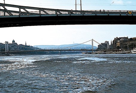
El Danubi a Budapest
© Fototeca.cat
Riu
Riu de l’Europa central que neix a la Selva Negra, a 1.078 m d’altura, prop de Donaueschingen i a menys de cent metres de la partió d’aigües amb el Rin (2.860 km de longitud i 817.000 km2 de conca).
Al començament s’encaixa en la plataforma calcària de Suàbia, empès pels afluents de la riba dreta Més endavant penetra en el massís cristallí de Bohèmia i hi obre gorges profundes, a l’entrada i a la sortida de les quals hi ha ciutats importants Passau, Linz, per exemple que han esdevingut nusos de comunicació i nuclis industrials El Danubi esdevé riu de plana un cop entrat a Hongria, prop de Budapest Travessa la conca de Pannònia i hi rep les aigües del seu gran afluent, el Tisza, quan reprèn la seva direcció normal oest-est, després del tram nord-sud…
Vojvodina
Divisió administrativa
Regió autònoma de la república de Sèrbia.
La capital és Novi Sad, seguida en importància per Subotica Comprèn una part de la Bačka, Sirmia i el Banat, i és formada per la gran plana alluvial del baix Tisza entre Romania i Hongria i limitada pel Danubi i el baix Sava És una fèrtil àrea agrícola, amb alts rendiments de bleda-rave, tabac, cànem i cereals És poblada per una majoria de serbis, amb minories importants d’hongaresos, croats, romanesos i eslovacs Al s IX formà part de l’imperi hongarès A partir del segle XI hi és esmentada per primera vegada la presència de pobles d’origen eslau Amb la conquesta dels Balcans pels…
Montreux
Ciutat
Ciutat del cantó de Vaud, Suïssa.
Situada a la vora dreta del llac Léman, forma, de fet, dos municipis Montreux-Châtelard i Montreux-Planches Nucli d’indústria tèxtil i alimentària, i centre turístic Hi tingué lloc, el 20 de juliol de 1936, l’anomenada convenció de Montreux, que definia el règim jurídic internacional aplicable als estrets turcs del Bòsfor i dels Dardanels Establia la llibertat de trànsit de les naus de comerç dels estats amb els quals Turquia no estigués en guerra, i la reglamentació del trànsit de les naus de guerra en temps de pau En temps de guerra, prohibició de trànsit als vaixells de guerra dels…